
The Milford Track is located on the southwest of South Island in the heart of spectacular Fiordland National Park.
Described by some as the finest walk in the world with beautiful scenery and waterfalls, Milford Track is popular not only among the locals, but people the world over. Even the two main menaces of the track – rain and sandflies – could not deter visitors / trekkers from visiting the place.
Friends who have been to the track constantly reminded me that there are more rainy days than otherwise. As for the sandflies, it is so plentiful and well known in the Milford region that the place where the track ends is called Sandfly Point!
There are two ways to do the trek: one as an independent walkers and another is to join the guided walk tour. We went as independent walkers and you would soon find out why!
The trek starts at Glade Wharf and ends at Sandfly Point. To get to Glade Wharf, one has to take a ferry from Te Anau Downs, about 29km from Te Anau town. And from Sandfly Points, take another ferry to Milford Sound. The cost for the ferry from Te Anau Downs to Glade Wharf was NZ$ 61.00 while from Sandfly Point to Milford Sound was NZ$ 32.00 (price as of November 2009)
A little note about Milford Track:
1. There is a limit of 40 people each day for the trek. So book early to avoid disappointment!
2. Trekkers stay in designated huts with very basic and minimum facilities. Toilets are located away from the huts. (Independent walkers stay at different chain of huts from guided walkers.)
3. No rubbish is to be left behind at the huts and in the park area. Whatever is taken in has to be taken out, including rubbish!
4. Food is not available for purchase on the track.
5. Kitchen with stoves is provided, but one has to bring own cooking utensils and food. Lightweight and easy to cook food is recommended.
6. No camping is allowed on the track.
7. Walkers have to carry their own belongings as there are no porters to carry it for you.
As independent walkers, we paid NZ$ 135.00 (NZ$ 45.00 per night) for the three nights stay along the trail.
The trail and the walk:
Day 1 – Glade Wharf to Clinton Hut, distance: 5km (1 – 1.5 hours)
Day 2 – Clinton Hut to Mintaro Hut, distance: 16.5km (6 hours)
Day 3 – Mintaro Hut to Dumpling Hut, distance: 14km (6 – 7 hours)
Day 4 – Dumpling Hut to Sandfly Point, distance: 18km (5.5 – 6 hours)
Total distance of the track: 53.5km
For those who are prepared to fork out big sum of money, you may choose to join the guided walk tour where food is provided, you get to stay in a much better and more comfortable accommodation and you walk with a guide. For that you would have to pay NZ$ 1,740.00 (for low season, more during high season)! Check out the website to find out more: http://www.ultimatehikes.co.nz/.
Now, you see why we chose to go as independent walkers! If you prefer to go as an independent walker, check out the official website: Dept of Conservation — Milford Track.
20100220
Milford Track – Map
 (Click on the photo to view larger version)
The above map is obtained from the Department of Conservation’s website: www.doc.govt.nz.
Milford Track – Profile

(Click on the photo to view larger version)
The above track profile is obtained from the Department of Conservation’s website: www.doc.govt.nz.
Day 1: Glade Wharf – Clinton Hut
Day 1 is a short and relatively easy walk. Twenty minutes after we started walking, we came to Glade House, the first overnight stop for guided walkers. A short distance away on the right was the first of the several toilet stops and on the left, we crossed the first and largest suspension bridge.
We were walking alongside Clinton River on our right. The water is crystal clear and the scenery was just… well, I could not find a more suitable adjective to describe it other than ‘spectacular, magnificent’!
And the weather? It was a fantastic sunny day! I enjoyed the walk so much that before I realised it, I was already at Clinton Hut, the first overnight stop for independent walkers.
In the evening, we followed the park ranger for a short walk while he gave us a briefing about the park, the fauna and floral of the region.
Dinner for the night was chicken curry with rice which we cooked the night before in Te Anau.
After dinner, the ranger returned to give us more briefing and having had a long day since morning, we retired to bed as soon as the briefing was over!
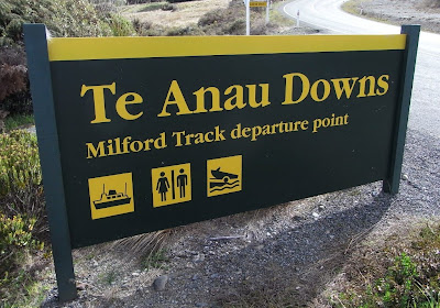 At Te Anau Downs. Here, we took ferry to
Glade Wharf, the starting point of the 4-day trek.
 Ferry terminal
 Close-up view of the ferry
 View from the ferry (above and below)

 This is just the beginning!
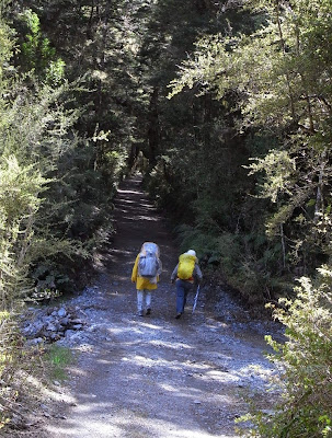 Along the trail – flat and pleasant trail
 Glade House – the first overnight stop for guided walkers

 About to cross the first and largest suspension bridge
 The trail continues
 Lunch break
Tuna / hardboiled egg sandwiches, fruit and mixed-nuts
 Magnificent view along the way (above and below)

 Clinton Hut (altitude 225m)
 For the purpose of head counts and safety reason,
walkers have to fill in the names on the table (right),
and the group ticket stub is to be placed in the container (left).
 Inside Clinton Hut (above and below)

 Weather forecast information
Rain, cloud, heavy falls, snow!
 The kitchen cum dining hall. Gas stoves are provided.
Trekkers have to bring their own cooking utensils and food.
 Overall view of Clinton Hut
 Surrounding area of Clinton Hut.
The area is surrounded by wetlands.


 Wetland area – the ground is soft and spongy
 Close-up view of the wetland (above and below)

 Briefing by the park ranger
We were walking alongside Clinton River on our right. The water is crystal clear and the scenery was just… well, I could not find a more suitable adjective to describe it other than ‘spectacular, magnificent’!
And the weather? It was a fantastic sunny day! I enjoyed the walk so much that before I realised it, I was already at Clinton Hut, the first overnight stop for independent walkers.
In the evening, we followed the park ranger for a short walk while he gave us a briefing about the park, the fauna and floral of the region.
Dinner for the night was chicken curry with rice which we cooked the night before in Te Anau.
After dinner, the ranger returned to give us more briefing and having had a long day since morning, we retired to bed as soon as the briefing was over!
At Te Anau Downs. Here, we took ferry toGlade Wharf, the starting point of the 4-day trek.
Ferry terminalClose-up view of the ferryView from the ferry (above and below)This is just the beginning!Along the trail – flat and pleasant trailGlade House – the first overnight stop for guided walkersAbout to cross the first and largest suspension bridgeThe trail continuesLunch breakTuna / hardboiled egg sandwiches, fruit and mixed-nuts
Magnificent view along the way (above and below)Clinton Hut (altitude 225m)For the purpose of head counts and safety reason,walkers have to fill in the names on the table (right),
and the group ticket stub is to be placed in the container (left).
Inside Clinton Hut (above and below)Weather forecast informationRain, cloud, heavy falls, snow!
The kitchen cum dining hall. Gas stoves are provided.Trekkers have to bring their own cooking utensils and food.
Overall view of Clinton HutSurrounding area of Clinton Hut.The area is surrounded by wetlands.
Wetland area – the ground is soft and spongyClose-up view of the wetland (above and below)Briefing by the park ranger Day 2: Clinton Hut – Mintaro Hut
At 16.5km, day 2’s walk was the second longest.
There are more rainy days in Milford Track than otherwise!
True to its reputation, we experienced the rain on day 2.
The scenery along the way, I have to say, was not as beautiful as day 1. Moreover, because of the rain and the cold weather, the mountain views were shied away by thick fog!
The trail is not as ‘flat’ as day 1, but it was not really difficult either though at times the walk was hampered by the rain a little.
The track also passes through many avalanche paths and signs are posted to warn walkers of the danger.
By the time we arrived at Mintaro Hut in the late afternoon, we were drenched! Little did we realise at that time that some ‘bad’ news was awaiting us!
The park ranger came by in the evening and informed us that it was snowing up on the mountain. If it started to snow during the night along the trail and the snow exceeded 400mm, then we would have to be flown out of Mintaro Hut to Dumpling Hut by helicopter the following morning as it would not be possible to walk on / through the thick snow. While some were cheering for it – it means less walking – it was not a welcoming news to most, as we would prefer to walk than to be on the helicopter. That’s what we came to Milford Track for!
More disheartening news!
The ranger continued by saying that if the weather was so bad that it rendered landing (of the helicopter) impossible, then we all would have to be grounded and stay for an extra day at Mintaro Hut.
SIGH!
The first thing that came to everyone’s mind was ‘how are we going to spend the extra day here without electricity and nothing else to do, and what about food!?’
‘I will drop by tomorrow morning around 8:00 to give you the latest news. Don’t leave the hut before then,’ with this reminder, the ranger left us.
We went to bed praying hard that the weather would be good the following morning!
Everyone kept their fingers crossed!
 Continuing our ‘big’ walk – 16.5km to go
and estimated walking time – 6 hours!
 Scenery is not as beautiful as that of day 1.
Moreover with the rain, mountains
were shrouded in mist / fog.


 Round-shaped toilet along the trail
 Long way to go!
 Warning and reminder signs (above and below)


 ‘Bus-stop’ – no bus would come by, just a pit stop!
 Mintaro Hut (altitude 600m)
 Drying our wet clothing and shoes (above and below)
 Inside the hut
There are more rainy days in Milford Track than otherwise!
True to its reputation, we experienced the rain on day 2.
The scenery along the way, I have to say, was not as beautiful as day 1. Moreover, because of the rain and the cold weather, the mountain views were shied away by thick fog!
The trail is not as ‘flat’ as day 1, but it was not really difficult either though at times the walk was hampered by the rain a little.
The track also passes through many avalanche paths and signs are posted to warn walkers of the danger.
By the time we arrived at Mintaro Hut in the late afternoon, we were drenched! Little did we realise at that time that some ‘bad’ news was awaiting us!
The park ranger came by in the evening and informed us that it was snowing up on the mountain. If it started to snow during the night along the trail and the snow exceeded 400mm, then we would have to be flown out of Mintaro Hut to Dumpling Hut by helicopter the following morning as it would not be possible to walk on / through the thick snow. While some were cheering for it – it means less walking – it was not a welcoming news to most, as we would prefer to walk than to be on the helicopter. That’s what we came to Milford Track for!
More disheartening news!
The ranger continued by saying that if the weather was so bad that it rendered landing (of the helicopter) impossible, then we all would have to be grounded and stay for an extra day at Mintaro Hut.
SIGH!
The first thing that came to everyone’s mind was ‘how are we going to spend the extra day here without electricity and nothing else to do, and what about food!?’
‘I will drop by tomorrow morning around 8:00 to give you the latest news. Don’t leave the hut before then,’ with this reminder, the ranger left us.
We went to bed praying hard that the weather would be good the following morning!
Everyone kept their fingers crossed!
Continuing our ‘big’ walk – 16.5km to goand estimated walking time – 6 hours!
Scenery is not as beautiful as that of day 1.Moreover with the rain, mountains
were shrouded in mist / fog.
Round-shaped toilet along the trailLong way to go!Warning and reminder signs (above and below)‘Bus-stop’ – no bus would come by, just a pit stop!Mintaro Hut (altitude 600m)Drying our wet clothing and shoes (above and below)Inside the hut Day 3: Mintaro Hut – Mackinnon Pass – Dumpling Hut
Day 3 was the highlight of the 4-day walk as it was the day we were going to cross the highest point, Mackinnon Pass.
We awoke early and waited for the park ranger expectantly.
Finally, we saw him. Well, the news was: ‘no extra night stay, no helicopter ride, but it would snow, so walk slowly and carefully.’
With that, we got ourselves ready and left the hut. About one hour into our long walk, it started to snow. Indeed, while having rain along the track was something of the norm, having snow during this time of the year (mid-November) was something we were not expecting. But, in anyway, we welcomed the snow with wide open arms! We enjoyed the walk in the snow. But not for long.
The snow became heavier and heavier; the wind, stronger and stronger. And it was freezing cold! The trail soon ‘disappeared’ under the snow. Following the footprints left behind by the trekkers ahead was the only way to identify the trail. When we came to the Mackinnon Memorial, the wind was so strong that we were literally ‘blown’ away! A quick stop to take a photo for memory was all we did and we moved on.
Soon, we came to Mackinnon Pass (1,154m), the highest point of our trek. Again, we stopped for a quick photo shot and then moved on as it was just too cold and windy to stop for any longer than it was necessary.
The Mackinnon Pass Day Shelter, located beyond the Pass, was a welcoming sight. It has a gas cooker and a kettle. We ‘took refuge’ from it, made ourselves some hot drink, had some snack and a short rest before moving on.
The toilet with the best view in Fiordland is located near the shelter.
After the pass, it was down hill all the way over rocky and uneven terrain. It finally stopped snowing and the wind abated. The sun made its appearance. It warmed our body and spirit a little before it started to drizzle… and then hailstones came a falling!
Along the way, there was also a track detour to be away from the high avalanche areas.
Rain, snow, sunshine, biting wind and hailstones – we saw it all, we experienced it all – all in one day! An eventful and a memorable day indeed. We were happy that we all made it without having to spend an extra night in Mintaro Hut!
 The trail
 Started to snow. Rachel welcomed
the snow with wide open arms.
 The trail partly covered with snow
 Ice!
Ice!

 The trail slowly ‘disappeared’ under the bleak weather.
 At Mackinnon Memorial. Freezing cold and biting wind!
 The trail ‘disappeared’ under the snow.
 Following the footprints of trekkers ahead of us.
 The Memorial viewed from afar
 At the Mackinnon Pass


 Mackinnon Pass Day Shelter
 Toilet with best view (located near the Day Shelter)

 The Shelter viewed from a distance


 Stopped snowing as we descended

 Unusual landscape
 Dumpling Hut (altitude 125m)
 Weather forecast for the following day – snow showers to 400mm!
We awoke early and waited for the park ranger expectantly.
Finally, we saw him. Well, the news was: ‘no extra night stay, no helicopter ride, but it would snow, so walk slowly and carefully.’
With that, we got ourselves ready and left the hut. About one hour into our long walk, it started to snow. Indeed, while having rain along the track was something of the norm, having snow during this time of the year (mid-November) was something we were not expecting. But, in anyway, we welcomed the snow with wide open arms! We enjoyed the walk in the snow. But not for long.
The snow became heavier and heavier; the wind, stronger and stronger. And it was freezing cold! The trail soon ‘disappeared’ under the snow. Following the footprints left behind by the trekkers ahead was the only way to identify the trail. When we came to the Mackinnon Memorial, the wind was so strong that we were literally ‘blown’ away! A quick stop to take a photo for memory was all we did and we moved on.
Soon, we came to Mackinnon Pass (1,154m), the highest point of our trek. Again, we stopped for a quick photo shot and then moved on as it was just too cold and windy to stop for any longer than it was necessary.
The Mackinnon Pass Day Shelter, located beyond the Pass, was a welcoming sight. It has a gas cooker and a kettle. We ‘took refuge’ from it, made ourselves some hot drink, had some snack and a short rest before moving on.
The toilet with the best view in Fiordland is located near the shelter.
After the pass, it was down hill all the way over rocky and uneven terrain. It finally stopped snowing and the wind abated. The sun made its appearance. It warmed our body and spirit a little before it started to drizzle… and then hailstones came a falling!
Along the way, there was also a track detour to be away from the high avalanche areas.
Rain, snow, sunshine, biting wind and hailstones – we saw it all, we experienced it all – all in one day! An eventful and a memorable day indeed. We were happy that we all made it without having to spend an extra night in Mintaro Hut!
The trailStarted to snow. Rachel welcomedthe snow with wide open arms.
The trail partly covered with snowIce!The trail slowly ‘disappeared’ under the bleak weather.At Mackinnon Memorial. Freezing cold and biting wind!The trail ‘disappeared’ under the snow.Following the footprints of trekkers ahead of us.The Memorial viewed from afarAt the Mackinnon PassMackinnon Pass Day ShelterToilet with best view (located near the Day Shelter)The Shelter viewed from a distanceStopped snowing as we descendedUnusual landscapeDumpling Hut (altitude 125m)Weather forecast for the following day – snow showers to 400mm!
Subscribe to:
Posts (Atom)